Puebla–Veracruz border, Mexico
Pico de Orizaba
3/5Overall difficultyChallengingA glacier-mountaineering objective on Mexico’s Citlaltépetl, approaching from Piedra Grande on the north side.
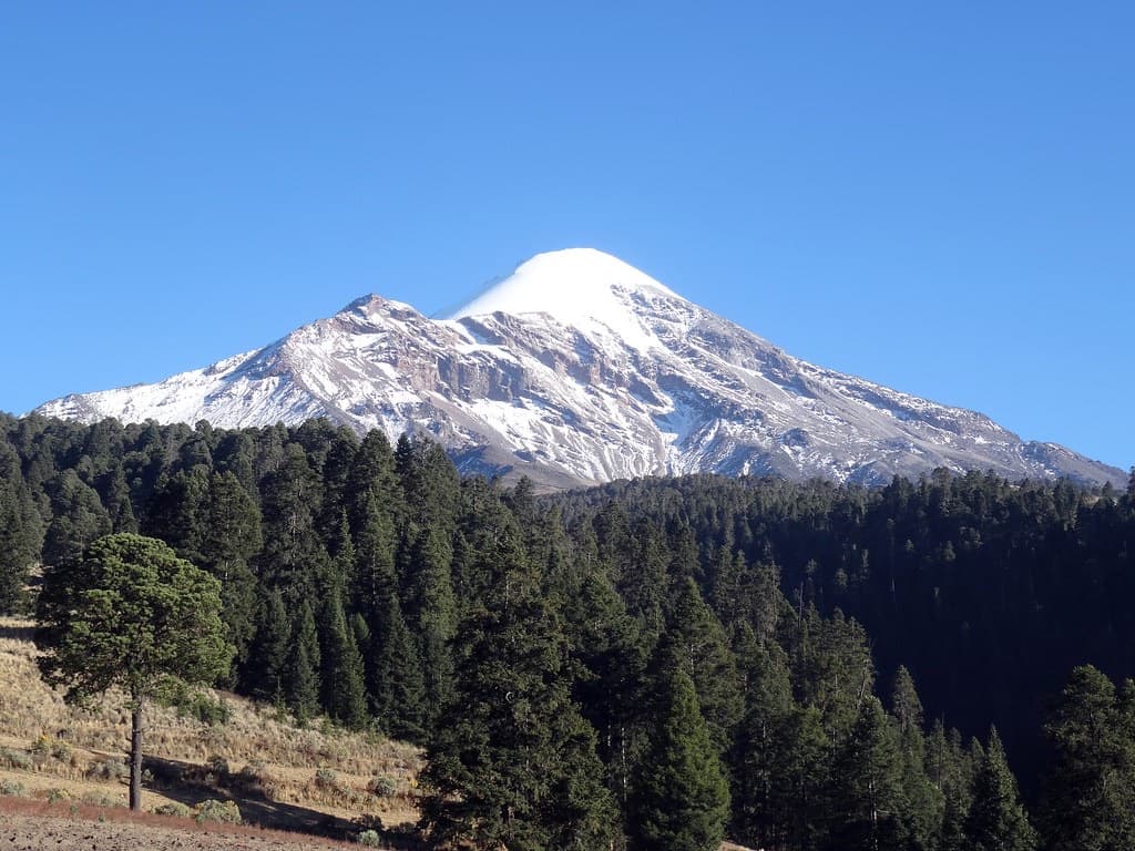 México en Fotos · CC BY-SA 2.0
- Distance
- Not available; see measurement notes
- Ascent
- ≈ 4,495 ft; see measurement notes
- Descent
- ≈ 4,495 ft; see measurement notes
- Time
- Usually 1 day; see measurement notes
Measurement notes
- Distance
- Distance review: The Jamapa approach changes with snow and glacier conditions. Altitude and operator summit-day estimates do not establish a reviewed full-return distance or cumulative ascent/descent for this precise corridor.
- Ascent
- Operator lists 1,369 m climb from Piedra Grande on the Jamapa summit day, rounded to 1,370 m. Net/source-listed climb is not independently measured cumulative descent or a current glacier-line survey. Route context only; not a training target, technical qualification or current-conditions report.
- Descent
- Operator lists 1,369 m climb from Piedra Grande on the Jamapa summit day, rounded to 1,370 m. Net/source-listed climb is not independently measured cumulative descent or a current glacier-line survey. Route context only; not a training target, technical qualification or current-conditions report. Estimated descent for the reviewed journey returning to its starting point, using the published ascent estimate and the same range or lower bound. This is a planning calculation, not a separately surveyed descent. Small undulations, detours and changing mountain routes remain subject to the ascent source’s limitations.
- Time
- One summit-and-return day from Piedra Grande in the cited itinerary. Excludes approach transport, acclimatization days and other volcanoes. Route context only; not a training target, technical qualification or current-conditions report.
The journey
- Piedra GrandeNorth-side start
- Rock and scree approachContinue toward the glacier
- Jamapa GlacierSnow and ice ascent
- Crater-rim summitSummit objective
- Piedra GrandeReturn along the same corridor
Route sequence only; use the official route information ↗ for navigation.
A demanding alpine climb, high-altitude objective or sustained trek. Glacier systems, exposed terrain, repeated long days or extended time at altitude add to the overall challenge.
For Jamapa Glacier — Piedra Grande summit and return.
How difficulty is rated
Our five levels combine physical effort, technical skills, altitude and overall commitment for the reviewed objective or route. Different challenges can lead to the same level; the numbers are broad bands, not equal steps in effort.
- 1 · Moderate
An introductory mountain objective or substantial hike. Expect sustained walking and climbing, sometimes on snow, without the systems or commitment of higher levels.
- 2 · Demanding
Long mountain days or multi-day treks with substantial climbing, carried loads, altitude or introductory alpine terrain. The combination requires deliberate preparation.
- 3 · Challenging
A demanding alpine climb, high-altitude objective or sustained trek. Glacier systems, exposed terrain, repeated long days or extended time at altitude add to the overall challenge.
- 4 · Very challenging
Sustained exposed technical climbing or a major expedition commitment. Technical complexity, heavy carries, altitude, remoteness or prolonged duration can drive this level.
- 5 · Extreme
An 8,000-meter expedition or another explicitly reviewed objective with comparable overall commitment. Exceptional altitude, expedition systems and sustained demands define this band.
Check the route details for the demands behind its level. Conditions and itinerary choices can change the challenge. This rates the objective, not your personal preparation.
Local training hikes have not been assigned an overall level. “Not rated” means no reviewed rating; it does not mean easy. They appear last when sorting by difficulty.
What to expect
- Crampon travel
- required
- Glacier
- glacier travel
- Roped glacier travel
- required
Before you make a plan
Check permits, reservations, access and current conditions for your chosen route and dates.
Sources and route notes
Piedra Grande through the north-side rock/scree approach to Jamapa Glacier, then the crater-rim summit and return to Piedra Grande by the same corridor.
Review through Dec 23, 2026. Historical maps and photographs do not establish current conditions.
crampon travel: Bounded to the named north-side operator route descriptions; no fixed glacier line, crevasse count or member skill assertion.
glacier: Bounded to the named north-side operator route descriptions; no fixed glacier line, crevasse count or member skill assertion.
glacier rope travel: Bounded to the named north-side operator route descriptions; no fixed glacier line, crevasse count or member skill assertion.
preview ascent: Operator lists 1,369 m climb from Piedra Grande on the Jamapa summit day, rounded to 1,370 m. Net/source-listed climb is not independently measured cumulative descent or a current glacier-line survey. Route context only; not a training target, technical qualification or current-conditions report.
itinerary days: One summit-and-return day from Piedra Grande in the cited itinerary. Excludes approach transport, acclimatization days and other volcanoes. Route context only; not a training target, technical qualification or current-conditions report.
Full reviewed claims and assumptions
What it asks of you
Objective-wide planning ranges apply only to the reviewed scope below. They are not a selected route profile, a fitness threshold, or evidence of your skills.
Reviewed scope and assumptions
- Reviewed scope
- Citlaltépetl summit identity in the north-side Piedra Grande / Jamapa glacier-mountaineering envelope; no route selected. Exact summit altitude remains unreviewed because official references disagree.
- Area
- Puebla–Veracruz border, Mexico
Crampon travel
required
Scope, sources and review
Explicit assumption
- Bounded to the named north-side operator route descriptions; no fixed glacier line, crevasse count or member skill assertion.
Reviewed 2026-09-24 · evidence expires 2026-12-23
glacier
glacier travel
Scope, sources and review
Explicit assumption
- Bounded to the named north-side operator route descriptions; no fixed glacier line, crevasse count or member skill assertion.
Reviewed 2026-09-24 · evidence expires 2026-12-23
glacier rope travel
required
Scope, sources and review
Explicit assumption
- Bounded to the named north-side operator route descriptions; no fixed glacier line, crevasse count or member skill assertion.
Reviewed 2026-09-24 · evidence expires 2026-12-23
Unlisted demands are not reviewed here; missing pack weights or weekly training targets are unknown, not zero. Confirm permit, access, equipment and conditions for your exact route and dates with the official sources.
Route-specific demand
Jamapa Glacier — Piedra Grande summit and return
- Reviewed scope
- Piedra Grande through the north-side rock/scree approach to Jamapa Glacier, then the crater-rim summit and return to Piedra Grande by the same corridor.
- Start
- Piedra Grande north-side hut/base-camp area; vehicle transfer excluded
- End and return
- Citlaltépetl summit via the crater rim; return by the Jamapa corridor to Piedra Grande
- Includes
- Piedra Grande through the north-side rock/scree approach to Jamapa Glacier, then the crater-rim summit and return to Piedra Grande by the same corridor.
- Excludes
- South-side/Fausto Gonzalez Gomar approach, Espolon de Oro, alternative glaciers, Sierra Negra, town transfers and any fixed acclimatization circuit
- Season assumptions
- Snow/glacier mountaineering context only; actual ice, snow, route line and access require current local assessment
- Itinerary assumptions
- Piedra Grande summit-and-return segment only; acclimatization, camp nights, porter support and daily schedule separately selected
Crampon travel
required
Scope, sources and review
Explicit assumption
- Bounded to the named north-side operator route descriptions; no fixed glacier line, crevasse count or member skill assertion.
Reviewed 2026-09-24 · evidence expires 2026-12-23
glacier
glacier travel
Scope, sources and review
Explicit assumption
- Bounded to the named north-side operator route descriptions; no fixed glacier line, crevasse count or member skill assertion.
Reviewed 2026-09-24 · evidence expires 2026-12-23
glacier rope travel
required
Scope, sources and review
Explicit assumption
- Bounded to the named north-side operator route descriptions; no fixed glacier line, crevasse count or member skill assertion.
Reviewed 2026-09-24 · evidence expires 2026-12-23
Route reviewed 2026-09-24 · review expires 2026-12-23. These demands apply only to this route and its stated assumptions.
Sources and review
- CONANP — Pico de Orizaba visitor identity and entry rules ↗
- CONANP — regional Orizaba page; conflicting geographic reference ↗
- Alpine Ascents — Pico de Orizaba itinerary ↗
- RMI Expeditions ↗
Reviewed 2026-09-24 · review expires 2026-12-23. Dates reflect operator review, not current route conditions — check conditions before you go.